
Translation Links
Français (French) Cliquez sur le lien pour la traduction en français :
انقر على الرابط للاطلاع على الترجمة العربية
ENVIRONMENT LOCATION-GEOGRAPHIC SETTING

Niha’s position within the northern Mount Lebanon mountain range
Niha occupies an elevated position within the northern reaches of the Mount Lebanon mountain range, in the Batroun District of North Lebanon. Set high above the Mediterranean coastline, the village sits within a landscape defined by steep ridges, deep valleys, cedar forests, and the clear mountain air for which this part of Lebanon has always been renowned.
The village is accessible from Lebanon’s coastal highway by two primary mountain routes, both of which wind through the characteristic landscape of terraced hillsides, historic towns, and cedar-forested heights that characterise the Batroun hinterland.
~100 km……….By road from Beirut
~40 km…………By road From Tripoli
1450m………….Elevation above sea level -peak of Niha mountain 1950m above sea level
Access routes from the coast
Two principal routes connect Niha to Lebanon’s coastal highway. Both pass through the historic towns of the Batroun region before climbing into the mountain terrain of the upper Batroun District.
- Route 1 · Northern coastal approach from Beirut-turn off Chekka
Via Batroun,
Jbeil (Byblos)-Batroun-Chekka-Kousba-Qnat-Marzaat Bani Saab-Niha
- Route 2 · Mountain highway approach from Beirut -turn off from Batroun
Via Ebrine and Kfarhilda
Jbeil (Byblos)-Batroun-Ebrine-Kfarhilda-Kfour al-Arbi-Niha
——————————————————————————————————————–
Walking Track – Darb El Maydi –
Niha to Kfour Arbi to Hardine
The historic hiking trail connecting the villages of Niha, Kfour El Arbi, and Hardine, formerly known as “Darb El Maydi,” has officially been rehabilitated and reopened through the collaboration of the concerned municipalities. The initiative aims to revive the region’s cultural and natural heritage while promoting eco-tourism and religious tourism.
The trail is considered an important spiritual and natural route linking several religious and scenic landmarks. At present, the path reaches the hermitages of Hardine, with future plans to extend and connect it to the temple site, the Monastery of Al-Riassa, Saint Sara Al-Hardini’s hermitage, and the Cross summit, before descending back toward Niha.
Work is also underway to organize and equip the trail according to recognized hiking safety standards, including the installation of directional signs, maps, and trail markers to ensure a safe and enjoyable experience for hikers, visitors, and nature lovers.
Currently measuring approximately 4 kilometers, the trail is expected to reach nearly 8 kilometers round trip once all planned sections are completed and interconnected.
The project aspires to create a space where nature, heritage, and spirituality come together, offering visitors and outdoor enthusiasts a unique destination that celebrates the beauty, history, and identity of the region.
see video link
Coordinates
For visitors planning their journey or researchers locating the village, the precise geographic coordinates of Niha – Batroun are as follows:
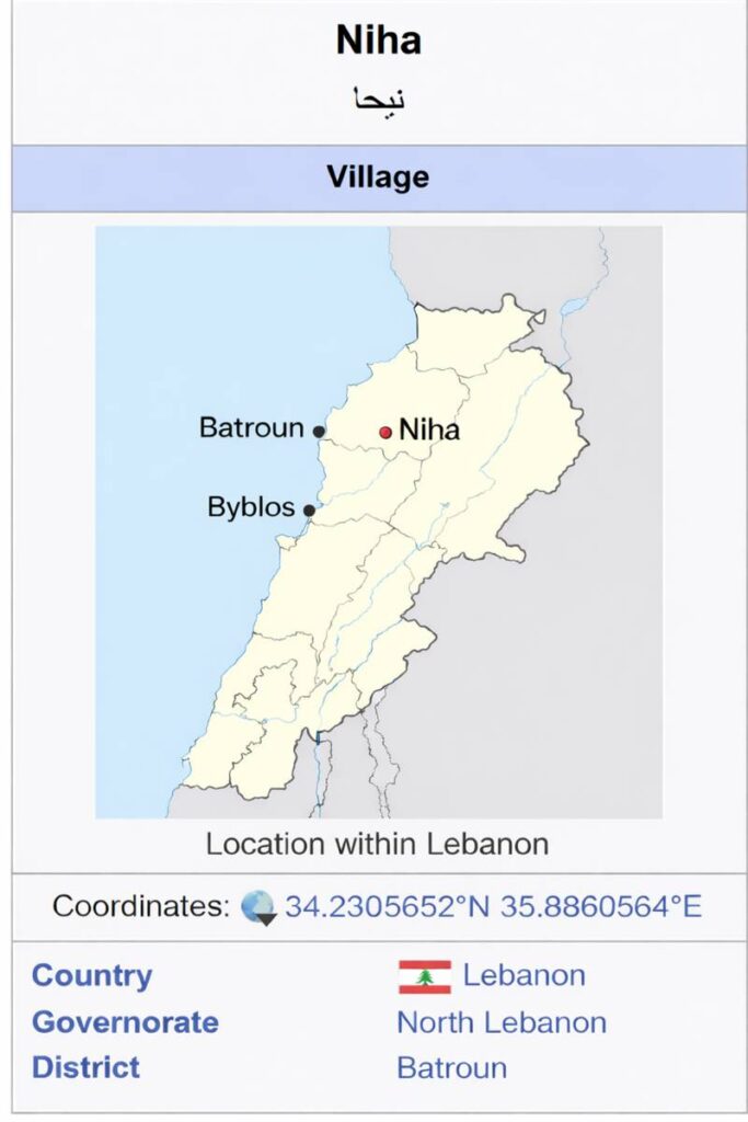
For visitors planning their journey or researchers locating the village, the precise geographic coordinates of Niha – Batroun are as follows.see map above
Water, agriculture and rural economy
- The natural systems and farming traditions that sustain Niha’s mountain life
Niha is sustained by several natural mountain springs and valley water sources distributed across the village terrain. These springs have been the lifeblood of the community for as long as Niha has been inhabited — supporting households, filling storage tanks, and irrigating the agricultural terraces that define the village’s landscape.
- Wadi al-Mizrab
- Nabi al-Kfour
- Wadi al-Shaw
- Wadi al-Raml
- Ayn al-Touti
- Tahouni
In addition to these principal sources, private wells and smaller springs are found throughout the village, supplementing the communal supply for individual households and farms.
Historic Hiking Trail “Medi Trail”
the rehabilitation and reopening of the historic hiking trail between Niha, Kfour al-Arabi, and Hardine, formerly known as the “Medi Trail,”
This trail is a tourist and religious route connecting several spiritual and natural sites. It currently ends at the Hardine Hermitages, with plans to extend it to the temple, then to the Monastery of the Patriarchate, the Hermitage of Saint Sarah al-Hardini, and finally to the Cross, before descending back towards Niha.
The trail will be organized and equipped according to approved safety standards for hiking trails, with the installation of directional signs, maps, and wayfinding markers, to ensure a safe and memorable experience for hiking and nature enthusiastsCurrently, the trail is approximately 4 km long, and will expand to nearly 8 km round trip once all sections are completed and connected.
This project is expected to create a space that blends nature, heritage, and faith, becoming a unique destination for every visitor and lover of the land and mountains.
Traditional water allocation — the time-share system
Water distribution in Niha has been governed for generations by a long-standing time-share allocation system, dating back to the very establishment of the village. Under this arrangement, each family receives access to spring water based on a combination of proportionate land ownership and traditional village agreements — a system of customary law that has ensured fair and orderly use of a shared natural resource across centuries of community life.
Recent water infrastructure development · 2025–2026
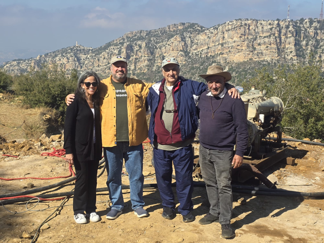
In 2025, the Municipality commenced a major upgrade to Niha’s water supply infrastructure — including the construction of a subsurface well drilled to 150 metres, a solar-powered pumping station, a 160,000-litre holding tank, and upgraded distribution piping. The project, completed in 2026 through diaspora funding, significantly strengthened both drinking water security and agricultural irrigation capacity across the village.

Agriculture, local produce and rural economy
Niha’s economy is rooted in the land. The village’s fertile alpine soils, reliable spring water, and mild summer climate support a productive and diverse agricultural tradition that has sustained its community across generations — and that continues today, now complemented by a growing commitment to organic and sustainable farming.
Produce
Apples Dairy products Goat meat Cedar honey Wild zaatar Sumac Potatoes Grapes Wine and arak
Cherries Pears Apricots Tomatoes Beans Onions Vegetables Homemade bread Labneh Goat milk products
Traditional village food production remains an important part of Niha’s heritage — homemade bread baking, labneh, and goat milk products are still made in the village and reflect a continuity of culinary tradition that connects contemporary Niha to its oldest way of life.
Organic farming and Cedar Scent
In recent years, Niha’s farmers have increasingly embraced organic farming principles — particularly in the cultivation of vegetables, fruits, and dairy — responding to both local demand and growing international interest in authentic, sustainably produced Lebanese mountain produce.
Historical Agricltural and forestry traditions
Pre-1950s
Wheat and mulberry
Niha’s principal commercial crops were wheat and mulberry. Mulberry leaves fed the silkworms central to Lebanon’s historic silk production industry — once a major source of village income.

Historic tradition
Cedar timber trade
Cedar trees from Niha’s forests were historically logged by relatives of the Tarabay family and transported by camel to Dayr al-Ahmar, where the timber was used in roof and building construction — a trade that reflected the forests’ deep economic as well as spiritual significance.
Contempory
Organic and artisanal
Today, Niha’s agricultural identity has evolved toward organic production, eco-tourism, and artisanal food heritage — building on its natural assets while adapting to the values and markets of the present.
The land has always been Niha’s foundation — from the cedar forests that once built roofs across Lebanon, to the wild zaatar that now reaches tables around the world. Agriculture is not simply a livelihood here. It is an expression of identity.

Eco-tourism and outdoor recreation
Niha has established itself as a recognised destination for eco-tourism and adventure-based recreation, drawing visitors from across Lebanon and beyond to experience its cedar forests, mountain terrain, and clean alpine environment. The village offers a rare combination of natural wilderness, cultural heritage, and outdoor activity — an experience that is increasingly rare and increasingly valued.
Natural environment
Niha sits within Lebanon’s northern alpine cedar belt — one of the most ecologically significant mountain landscapes in the country. The village occupies an elevated ridge environment defined by cedar forests, agricultural terraces, steep mountain slopes, and naturally occurring springs and valleys. Its high altitude, challenging terrain, and relatively undisturbed character have together preserved fragile ecosystems and supported rich biodiversity across the centuries.
Connection to the Tannourine Cedar Reserve
Niha sits adjacent to, and forms part of, the greater cedar ecosystem associated with the Tannourine Cedar Forest Nature Reserve — a protected region recognised for hosting one of the highest densities of Lebanese cedar trees in the country.
The reserve is dominated by Cedar of Lebanon (Cedrus libani) mixed forest, with areas of scrub, rocky canyon, and fast-flowing streams. It is part of the largest remaining Cedar forest in Lebanon, and supports a wide range of mammals including Persian Squirrel, Badger, Wild Boar, and the rare Wolf.
The reserve protects 625 hectares of the largest and most dense cedar forest in Lebanon, with over 2.5 million trees — cedars accounting for more than 80% of the total. It was formally established as a protected area on February 25, 1999, under Law No. 9, and is managed by a committee in cooperation with the Ministry of Environment.
The reserve is located on an important migratory route for large soaring birds, particularly Lesser Spotted Eagle and Greater Spotted Eagle. and is also notable for bats and breeding birds, as well as entomological and herpetological species recorded by scientific teams.This proximity places Niha within one of Lebanon’s most important conservation landscapes, reinforcing the village’s role as a steward of the cedar heritage central to Lebanese national identity.
- Official site of the Tannourine Cedar Forest Nature Reserve
www.tannourinecedarreserve.org
- Detailed birding guide to the Tannourine cedar reserve and surrounding region
The Tannourine reserve — and Arz Niha within it — is not simply a forest. It is one of the last places in Lebanon where the cedar landscape that defined this country for three thousand years survives largely intact. Its protection is an act of cultural as much as ecological preservation.

Forests and tree species
The dominant and most iconic presence in Niha’s landscape is the Cedrus libani — the Cedar of Lebanon — native to this region and inseparable from Lebanon’s national identity, its flag, and its ancient history. Around the cedar, a community of companion species completes the forest ecology of the upper Batroun highlands.
Native · Iconic
- Lebanese Cedar-Cedrus libani
The defining tree of Niha’s landscape and Lebanon’s national emblem — ancient, protected, and central to the village’s identity and eco-tourism
Native
- Conifers
Various species
- Native conifer species complementing the cedar across the upper alpine terrain
Traditional
- Oaks Quercus sp.
Traditionally planted near churches; historically the gathering point under which clergy educated village children and held summer parish meetings
Plants, wildlife and the Tannourine Cedar Reserve
- The ecological richness of Niha’s cedar mountain landscape
- Plants and wild growth
Beyond its forests, Niha’s high-altitude environment supports a diverse and ecologically significant plant community. The combination of mountain springs, rocky terrain, and an undisturbed alpine climate creates conditions that sustain species rarely found at lower elevations.
Wild mushrooms Wild oregano Wild thyme (zaatar) Chickpeas Seasonal alpine flowers Mountain tulips — rare Lebanese prickly thrift — rare
Among the most ecologically notable finds are rare high-altitude flowering species — including mountain tulips and the Lebanese prickly thrift — whose presence reinforces the significance of Niha’s landscape within Lebanon’s broader biodiversity. These species are indicators of an intact and largely undisturbed alpine ecosystem, adding scientific and conservation value to the village’s natural environment.
Wildlife and fauna
Niha’s cedar belt and surrounding mountain terrain support a varied community of mammals, birds, and other wildlife — including species that are rare, protected, or in long-term decline across the wider region. Two species of particular historical and ecological significance were once native to these forests but have been lost within living memory.
- Locally extinct – Nubian Ibex – Capra nubiana
Once native to Lebanon’s cedar forests, the Nubian ibex has been extinct in this region for more than a century — a loss that reflects the broader pressures on Lebanon’s highland fauna over the past two hundred years.
- Locally extinct – Syrian Brown Bear – Ursus arctos syriacus
The Syrian brown bear was native to Lebanon’s cedar forests and is believed to have disappeared from the country in the 1950s — another marker of the ecological change these mountain landscapes have undergone.
Despite these losses, Niha’s landscape continues to support a meaningful variety of wildlife. The following species have been recorded in and around the village:
Mammals- Wolves (rare) HyenasPersian squirrels Wild boar Badgers Bats Snakes
Birdlife – Eagles Hawks Owls Robins Sparrows

Migratory Birds and International Importance
The Tannourine Cedar Forest Nature Reserve is designated as an Important Bird Area (IBA) by BirdLife International, due to its ecological role in supporting diverse avian species.
Research notes that the reserve serves as:
- a resting site for approximately 156 migratory bird species, and
- a breeding habitat for rare species such as the Blue Titand the White-throated Robin
In total, approximately 71 bird species have been recorded in the reserve.
Niha itself receives significant migratory bird movement, with an estimated 20,000 migratory birds passing through mainly during Spring and Autumn. Around 15 different migratory species are known to rest in the cedar forests of the village, including large flocks of White Storks.

SEASONAL HIGHLIGHTS
- Niha through the year — four seasons, each with its own character
Niha is a village shaped by its seasons. The same landscape that sits snowbound and still in January becomes lush and fragrant in May, vibrant with returning families and harvests in summer, and golden with mushrooms and orchard fruit in autumn. For those who know the village, each season carries its own particular quality — its own reason to return.

- Spring March — May
Spring is perhaps the most visually dramatic season in Niha. As winter’s snow retreats from the surrounding peaks, the alpine terrain undergoes a rapid transformation — the mountains drawing a green blanket of wild vegetation almost overnight, dotted with wildflowers, ground covers, and orchids in bloom across the high slopes.
Snowmelt feeds rapid streams and seasonal waterfalls that cascade through the village terrain, running strongly through spring before subsiding by mid-summer. Fruit trees flower across the terraces, adding colour and fragrance to every pathway and viewpoint.
Spring is considered one of the finest times for panoramic views from Niha — the air is clear, the visibility exceptional, and on many days the eye travels unbroken from the full sweep of the Mount Lebanon range to the blue line of the Mediterranean coastline.
- Wildflowers and orchids Alpine bloom across the high terrain
- Seasonal waterfalls Fed by snowmelt; strongest in April–May
- Fruit tree blossom
- Terraces in colour across the village
- Panoramic views
- Clearest visibility of the year

- Summer June — September
Summer is Niha at its fullest. While Lebanon’s coastal cities endure humidity and heat, the alpine climate of the Mount Lebanon range offers relief that has drawn people to the mountains for generations. Niha shares this advantage fully — with average daytime temperatures of approximately 26°C, cool evenings, and minimal rainfall from May through September.
What is less widely known — except among Niha descendants and long-time visitors — is that the village’s elevated position and the surrounding limestone formations are traditionally believed to carry notable health and wellbeing benefits. This reputation has accompanied Niha for as long as people have lived here.
Summer brings the village back to life. Residents from Lebanon’s coastal cities return regularly for weekends, the drive often taking under an hour. Many families spend the entire season in Niha, commuting to work from the mountain. They are joined each year by diaspora visitors — often reaching the third or fourth generation — who travel from Australia, the Americas, France, and Guadeloupe to spend weeks or months in their ancestral homes or newly built residences.
Summer harvest periods
Cherries — May / June Apples and pears — September / October Walnuts — October
On summer evenings, cloud formations occasionally envelop the village briefly — creating the rare sensation of walking above the clouds, the valleys below disappearing in white. Niha’s sunsets are among its most cherished experiences.
Social life in summer is rich, traditional, and unhurried. Families gather around card games — Likaa (Four Hundred) and Tarnib — and the smell of wood-fired bread baked on the traditional sorj drifts through open windows. Outdoor life centres on the cedar forests, the springs, and the tracks that wind across the alpine landscape.
- Hiking and forest walks
- Cedar trails and spring treks
- Saydet Al-Qalaa pilgrimage
- August grotto chapel visits
- 4WD alpine exploration
- Cross-country mountain tracks
- Traditional card games
- Likaa, Tarnib, backgammon
- Autumn October — November
Autumn is a season of gradual departure and quiet preparation. Many families begin returning to their coastal homes — a large proportion of Niha residents today maintain homes in the Byblos region — while the village settles into a gentler rhythm of harvest and orchard work.
Wild mushroom picking in the cedar forests is one of the season’s most cherished activities, while farmers undertake orchard pruning and maintenance to prepare for the following summer’s growth. Rainfall typically resumes between late September and October, continuing through to April.
Autumn also carries a thread of deeper history. Niha families historically owned land in the Koura district and moved there for winter — working olive plantations to produce oil for household use and for sale, while Niha itself was snowbound. Over generations, some families settled permanently in the Koura region, in areas including Haret El Khalsa, En Nakhle, Ras Masqa, and the Haykaliyeh area. Much of this land was purchased using funds brought back from overseas work in the Americas, dating to the late nineteenth century.
- Wild mushroom picking
- Cedar forest foraging season
- Orchard maintenance
- Pruning and preparation for summer
- Rainfall returns Late September through to April

- Winter December — March
Winter in Niha is a season of extraordinary beauty and considerable isolation. The village empties to a skeleton community of approximately six permanent families, who remain to care for livestock and safeguard properties through the cold months. Children travel daily by bus to schools in nearby areas.
Snowfall typically arrives between November and April. Due to Niha’s high elevation, winters are cold and wet — the village and its surrounding mountain terrain are among the highest-rainfall localities in Lebanon. The landscape becomes a white expanse of snow-capped ridges, the cedar forests carrying their heavy loads of snow in deep silence.
1973
Historical records note an exceptionally heavy snowfall covering the village to a depth of approximately four metres — one of the most severe winters recorded in living memory.
1982
A second exceptional snowfall of similar magnitude — further evidence of Niha’s position within Lebanon’s highest-precipitation mountain zone.
Despite its severity, the village remains accessible throughout winter. Government road services typically keep the access road open, and the isolation is one of partial rather than complete disconnection. For those who experience it, winter in Niha is one of its most atmospheric and memorable seasons.
- Cross-country skiing Through the alpine terrain and cedar forests
- Snowshoeing
- Village and forest winter walking
- Snow season
November April; peak Dec — Feb
In spring the mountain blooms, in summer it fills with people; in autumn it releases them gently; in winter it keeps only those who truly belong to it. Niha’s seasons are not just weather — they are the are a living community